Geography Pages
How to draw a Map of Israel
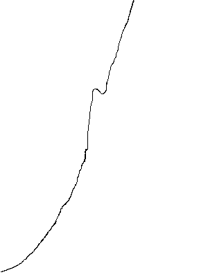
| 1. Draw a slightly curved slanting line, with a hook about one third from the top. This is the coastline The Mediterranean Sea is to the left (West) The "hook" is the Bay of Acre (also called Acco) or Haifa, and is the only good natural harbor along the coast Caesarea was also a harbor, but was artificially made when the Romans found out how to make cement which would set under sea water Most of the coast consists of smooth golden sandy beaches which slope gently into the sea and are not good for large boats |
 |
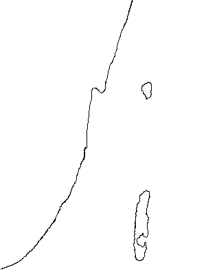
| 2. Draw Lake Galilee as a rough triangle with one point facing west, about on a line with the Bay of Acre Lake Galilee is also known as the Sea of Galilee, though it is basically fresh water (now with a high concentration of salts) rather than salt water. Other names for Lake Galilee are the Sea of Chinnereth, or Kinneroth (because it is shaped like the type of harp called a Kinnor); the Sea of Tiberias, because of the town of Tiberias on its south western edge; and the Lake of Gennesaret Draw the Dead Sea at the bottom of the map, on the same north-south line as Lake Galilee. The Dead Sea is a roughly elongated oval, with a peninsular jutting out on the lower eastern shore. The shape of this part of the Dead Sea varies as the water is pumped out and evaporated to recover the salts dissolved in it The Dead Sea is also known as the Salt Sea, the Sea of Arabah, and the Sea of Sodom Sodom and Gomorrha probably lie beneath the waters of the Dead Sea, on the south east region below the peninsular The Dead Sea is the lowest point on the earth's surface - the shore line is 1,294 ft. below sea level, and the lowest point of the Sea is 1,300 ft below that Lake Galilee is also about 700 ft. below sea level |
 |
| 3. Draw the Jordan River as a wiggly line between Lake Galilee and the Dead Sea 4. Draw the northern stretch of the Jordan coming from the north and entering the northern point of the Sea of Galilee There are in fact several small rivers which come from the region of Mount Hermon and join to form the Jordan to the north of Lake Galilee, but it is generally sufficient to show just the main one The Jordan between Lake Galilee and the Dead Sea is the world's lowest river. It is extremely winding, and has never been of use for navigation : it takes 200 river miles to travel 65 direct miles south to the Dead Sea, with a drop in elevation of only 600 ft Lake Galilee, the Jordan, the Dead Sea, and the Red Sea further south all lie in the Great Rift Valley System that stretches north-south from southern Turkey to the Zambesi River in southeast Africa. This part of the Great Rift System is known as the Arabah |
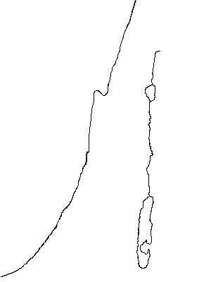 |
| 5. If you want to be really classy, draw the Jabbok River a bit more than half way down from the Sea of Galilee to the Dead Sea | 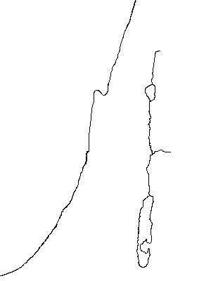 |
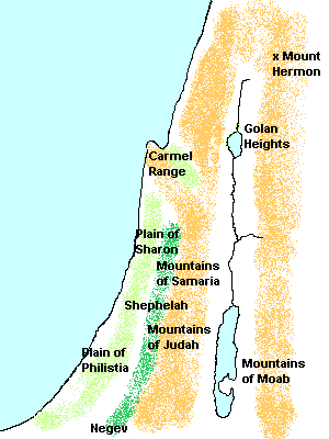
| 6. Physical Geography The bit that juts out on the coast line is due to the cliffs of a mountain ridge from Mount Carmel Mountains (brown) form a wide limestone ridge running north-south parallel to the coastline, and also north-south to the east of the Jordan Valley The coastal plain (pale green) used to be marshy and plagued with malaria; it has now been drained, and is used for agriculture. To the north it is called the Plain of Sharon. The southern part was called the Plain of Philistia because the Philistines invaded (by sea) and settled along the plain. The name "Palestine" used by Arab people to refer to the land comes from "Philistia" The large flat valley (pale green) just to the north of the Carmel range is the Valley of Esdraerlon, which leads into the Plain of Jezreel. This was (and still is) a major route from the coastal plain to the Galilee and the lands to the north and east The foothills (dark green) are called the Shephelah The desert to the south is called the Negev or Negeb |
 |
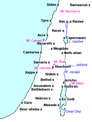
| 6. Towns : Start with Jerusalem : on a line with the top of the Dead Sea, almost half way to the coast. Jerusalem is at the top of the mountain range which runs through Israel Bethlehem is 5 miles south of Jerusalem and a bit west Jericho is 6 miles north of the Dead Sea, and a bit to the west Qumran (where the Dead Sea Scrolls were found) is at the northwest corner of the Dead Sea Masada (the mountain fortress where in AD 72 the Zealots held out against the Romans, and committed suicide rather than be taken captive) is on the west coast of the Dead Sea, near the place where it becomes a narrow channel En Gedi is nearer to Masada than to Qumran Beersheba is almost half-way between the Dead Sea and the Mediterranean, south of Masada, north of the end of the Dead Sea Hebron is south of Jerusalem and Bethlehem, about on a line with the middle of the Dead Sea Gaza is on the coast, on a line half way between Hebron and Beer-sheba Shechem is on a line with the Jabbok River, and a bit east of the half-way point between the Jordan Valley and the Mediterranean Mt. Ebal and Mt. Gerizim are either side of Shechem Bethel is one third the way between Jerusalem and Shechem Shiloh is two thirds the way between Jerusalem and Shechem, and a few miles to the east Starting at the projection caused by the cliffs of the Carmel Range, visualize the slanting line of the Carmel Range. Megiddo is nearly half-way between the coast and the Jordan Valley, and Beth-shan is almost at the Jordan. These two citadels controlled the highway from the coast to the lands to the east and the north Caesarea is on the coast, roughly in line with Beth-shan. Caesarea was founded by Herod the Great ca. 30 BC, on the site of an earlier town, and named in honor of the Roman Caesar Acco (Acre), Tyre, and Sidon are spaced roughly equally up the coast Damascus is on a line with Sidon Dan and Banias are on a line with Tyre Capernaum is on the top north east side of lake Galilee |
 |
Copyright © 1999 Shirley J. Rollinson, all Rights Reserved
![]()
![]()